UPDATED:
11/08/2024 06:49 PM
Key Details
Property Type Vacant Land
Sub Type Land/Acreage
Listing Status Active
Purchase Type For Sale
Square Footage 876,862 sqft
Price per Sqft $3
MLS Listing ID 23-245196
Originating Board Washington County Board of REALTORS®
Annual Tax Amount $1,547
Lot Size 17.000 Acres
Acres 17.0
Property Description
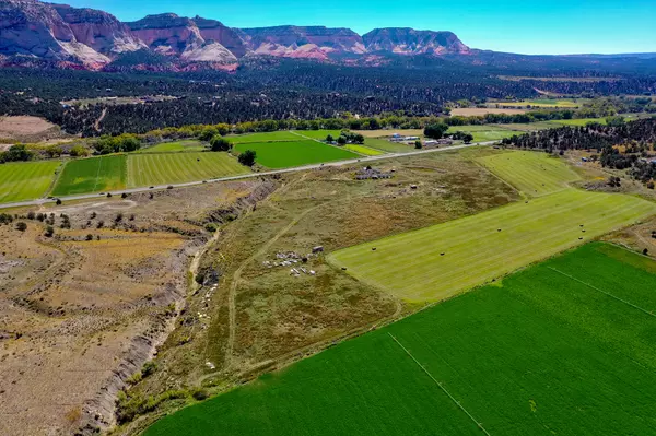
Located just 20 minutes from the East entrance of Zion National Park and the proposed new East ZNP visitor center. This beautiful property with views is one of the last larger commercially zoned parcels close to Zion NP. Easy access right off highway 89 and is perfect for tourism-based businesses. The property includes 50 shares of pressurized irrigation along with culinary water & power. Additional shares are available. Includes partially built concrete structures.
Contact Agent for information regarding the Proposed Cove Reservoir Project (in cooperation with Washington County Water Conservancy District, Bureau of Land Management, and National Park Service). * Long-term use of the proposed reservoir would provide important recreation opportunities for both local residents as well as visitors to the area. Because the reservoir would be located near US-89, convenient access to the site would make it attractive to potential users. Existing recreation areas, including national and state parks, are becoming overcrowded (Salt Lake Tribune 2018; Yale Environment 360 2017). The proposed reservoir and associated facilities could provide an overflow opportunity to nearby recreation sites. Recreation opportunities would include water-based activities such as non-motorized and small motorized boating, swimming, and fishing. Non-water activities would include picnicking, overnight and day camping, and sightseeing. (* Source - Draft Watershed Plan and Environmental Assessment for the proposed Cove Reservoir Project dated October 2020)
Minimum 24 hour notice for showing/meeting on site.
Location
State UT
County Other
Area Outside Area
Zoning Commercial
Direction North on Highway 89 from Mt. Carmel. Land is on the left before Orderville City. GEO: 37.263222, -112.6355275
Exterior
Utilities Available Culinary, City, Electricity Connected
View Y/N No
Building
Lot Description Access, Deeded Esmnt, Access, Public, Irrigation Water, View Mountains
Schools
School District Out Of Area

GET MORE INFORMATION

Kelli Stoneman
Broker Associate | License ID: 5656390-AB00
Broker Associate License ID: 5656390-AB00


